
. Introduction
In Poland, the work on increasing the availability of cadastral data has been ongoing for many years. The Main Office of Geodesy and Cartography has taken many initiatives aimed at providing access to increasingly accurate and detailed cadastral information. In the public perception, the cadastral data are one of the most important sources of information about property ownership, rights associated with it and the scope of their validity. But the cadastre is not only a register of plots, but also there are many related tasks. In accordance with art. 21 of the Act on Geodetic and Cartographic Law (Act, 1989), the data contained therein constitute the basis for economic planning, spatial planning, the assessment of taxes and benefits, marking real estate in land and mortgage registers, conducting official statistics, real estate management and farm records. Taking into account the essential functions and areas in which it is used, it should guarantee safety and maintenance order associated with both the data disclosed therein as well as individual rights. However, in order to administer and manage real estate rationally, it is not only required to collect information about real estate in terms of the timeline data contained therein, but also necessary to be able to easily view archived data, currently out of date, or rights incumbent on the property in the future, such as easement. Creating a multidimensional and multifunctional cadastre would also allow reviewing other temporary rights on real estate, such as perpetual usufruct or easement. The cadastre should provide relevant information not only in relation to a reasonable point in the cadastral space, but also in relation to a given point on the time axis (Szeliga, 2005). This will not only increase safety or increase governance, but also allow to perform various types of analyses.
The collection of time data results not only from the need to improve standards or improve the cadastre, but also from the recommendations of international law. Admittedly, the main task of norms and standards on a European scale is to enable easier data exchange and unification of systems collecting them, and also to initiate the creation of a full and multifunctional cadastre. These standards in the description of conceptual models naturally refer to the importance of the aspect of time. They emphasise the need to collect data, and not just to replace them with more recent data. Although time has always played an important role in cadastre so far, it has been treated quite independently of the spatial aspect (van Oosterom et al., 2006).
The basic research thesis of this work is the statement that the legal regulations existing in Poland ensure adaptation of the cadastre to international norms and standards in the context of creation or modification of time data.
This article aims to look at the current Polish legal regulations regarding the possibility of placing much greater emphasis on the collection, storage and use of time data. This analysis was performed in compliance with international standards. The basic acts taken into account were ISO standards (ISO 19152, 2012) and the INSPIRE Directive (Directive, 2007). Although many publications have been created comparing the Polish cadastre with international standards or assessing the possibility of its implementation (Bydłosz, 2012; Góźdź et al., 2014; Wróblewska and Pachelski, 2016), as well as assessing the Polish cadastre (Dawidowicz and Źróbek, 2018; Mika, 2018; Siejka et al., 2014), however, they did not refer directly to the aspect of time and only referred to the overall possibility of its introduction.
. Methodology
The main objective of this article is to discuss the legal issues related to the possibility of registration of the aspect of time in the Polish cadastre. The research procedures used qualitative methods, especially the methods of analysis and logical construction, including identification. This paper includes analyses of both Polish legal regulations and European standards and norms. Finally, the article presents the results of comparative analyses concerning the data model of cadastre and INSPIRE and LADM data models for the theme cadastral parcel in terms of temporal aspect. The results of the conducted research will become the basis for creating some guidelines that will allow to optimise the Polish standards related to the time of creation or modification of cadastral objects.
Due to the fact that the basic cadastral object in Poland is a cadastral plot, an analysis was carried out on its example. It is, in fact, an identifiable cadastral object that allows building relations between subject and object data (Ciak and Wąsewicz, 2015). All reports and time information related to changing borders or legal changes also apply to it. Therefore, the plot is the basis for the current cadastral model.
. Polish law in the context of the aspect of time in the cadastre
The law in Poland describing the model for recording cadastral data is the Regulation of the Minister of Regional Development and Construction of 29 March 2001 on the register of land and buildings (Regulation, 2001). In accordance with art. 2 point 8, ‘the cadastre shall be understood as an information system ensuring collection, updating and sharing, in a uniform manner for the country, information about land, buildings and premises, their owners and other entities owning or managing these lands, buildings or premises’. It follows from this provision that the basic task of the authorities running the property cadastre is to ensure that the data contained therein are up to date. Therefore, in most cases, institutions focus only on the aspect of timeliness of shared data, thus neglecting the care of archiving data, no longer binding and ensuring the possibility of combining it with current data. Although some outdated data are available in a cadastre, this is rather due to the unconscious operation of the employees entering the registration data. Although the centres currently keeping records do not focus on archival data, the legislature has given them the opportunity to enter new data not only by replacing them with earlier data, but also by introducing subsequent versions for a simple reference to earlier states.
In Annex 1 to the Regulation (2001), we find the Unified Modeling Language (UML) application diagram for cadastral data. Already in the scheme of the general object (Figure 1) we can notice not only the attribute the start of the Object, the end of the Object, but also the start of the Object version and the end of the Object version. This entry suggests that every cadastral object that has been modified should be treated as an older version, not replaced by a newer one. In addition, the scheme allows to enter a reference to the legal attitude of creating another version of the object. However, for this to be possible, it is necessary to have an object version identifier positive in the object identifier. This would greatly facilitate the possibility of analysing data or finding changes and the legal basis for their creation. This solution would work, for example, at border points. It would allow you to make changes to improve the value of point attributes such as a position error or a data source.
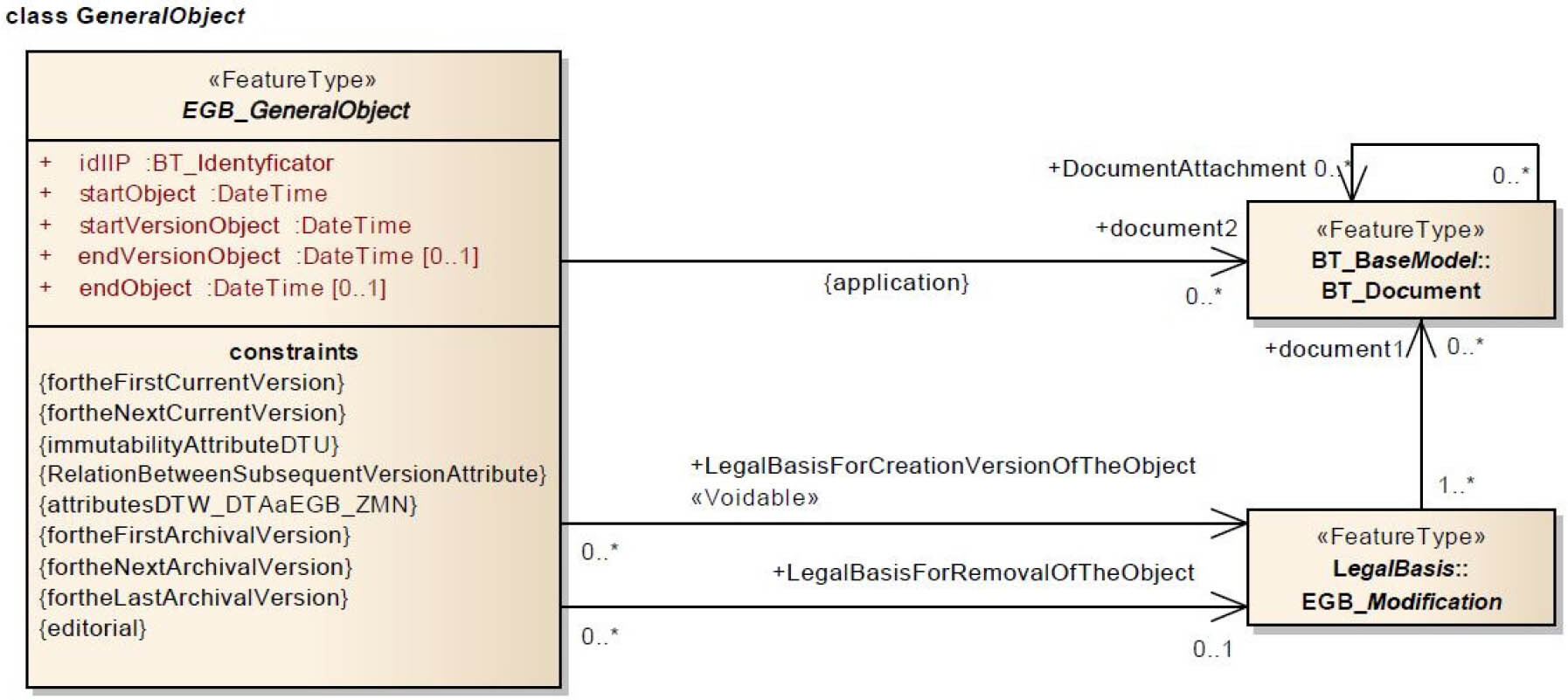
In the restrictions related to the object (Figure 1), you can see further solutions related to the time of creation or modification of cadastral data. The legislator not only included in them the option of entering the last version of the object, but also delimited the parameters of the first archive version, the last archive version and the next archive version. The scheme also shows the possibility of dependencies between the attributes of subsequent versions,, which is very important when recreating history or performing analysis.
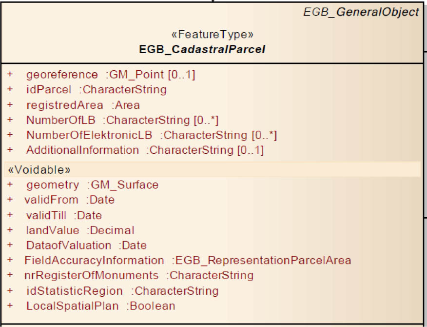
The basic object of the cadastre, which is a plot in its application scheme, also has the option of entering the validity and validity attribute (Figure 2). However, at present, it is not a mandatory attribute and is therefore not usually supplemented by the record-keeping authorities. This would be a very useful attribute, not only when dividing a plot, where we have an evident change in its number, but also when working on improving specific attributes of border points.
The Regulation Regulation (2001) also refers to the possibility of introducing the version of an object into the registration data in the context of spatial objects of spatial information infrastructure. In § 16 is given the following: ‘registration plots, buildings and premises as well as persons and organizational units, as well as other registration database objects are marked in the records and with appropriate identifiers’. Section 3 of this paragraph states that one part of this identifier is intended to be a version of the object.
Although these provisions are practically not used in the current cadastre, they indicate the importance of the aspect of time specified in the current register by legislators.
. International standards indicating the need to record time data
Virtually, every country has developed its own property administration and management system. Although these systems differ from country to country, they have one thing in common – they are based on relationships between entities and real estate (Bydłosz, 2012). However, in order to talk about a multidimensional, and also multitasking cadastre, it should be uniform globally and thus enable data exchange between countries. Therefore, when building the cadastre in Poland, we must not forget about international standards and guidelines that aim to standardise the cadastre. The basic standards for cadastral data, including the storage and handling of time data, are the ISO standards (ISO 19152, 2012) and INSPIRE Directive (Directive, 2007). Due to the fact that both INSPIRE and ISO 19152 standards were developed in parallel, the teams creating them cooperated with each other to ensure consistency and compatibility between regulations. This enabled matching terms and definitions in both of these acts. Although there are differences between these acts, even in the areas concerned with the application of the standards, partial compliance makes it possible to ensure that national legislation complies with both INSPIRE and ISO standards.
. ISO 19152 ‘LADM’
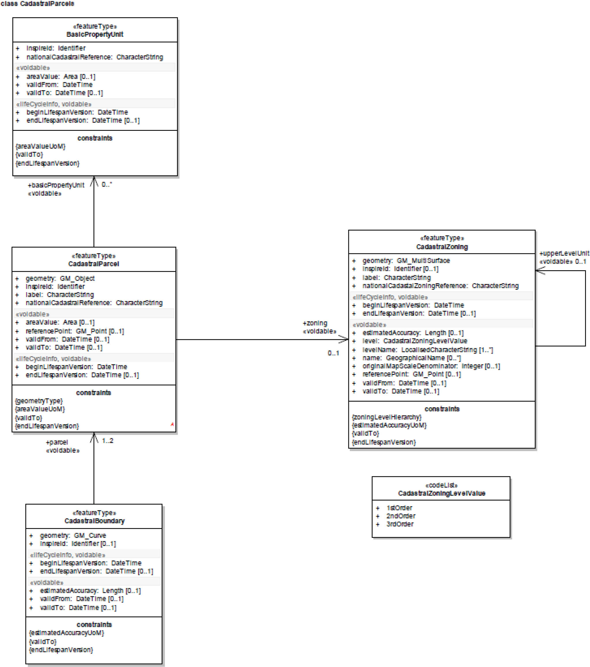
The first provision of international law that should be taken into account when considering the aspect of time in the context of cadastral data is the standard of 19 November 2012 ISO 19152 ‘LADM’ (ISO 19152, 2012). In Poland, this standard was published by the Polish Committee for Standardization on 30 May 2013 under the name ‘Geographic Information – Cadastral Model of Land Administration’. LADM is a descriptive standard whose primary purpose is not only to provide a formal language to describe existing property registration systems, but also to enable communication based on common vocabulary, both within a given country and between countries. First of all, the ISO 19152 standard is related to property rights, obligations and restrictions. It allows the harmonisation of the rights and owners of cadastral objects in three dimensions. In addition, it aims to support legal security, taxes, valuation and spatial planning. Therefore, one can notice the compliance of these tasks with the objectives of the Polish cadastre. In addition, LADM provides a conceptual model whose primary classes are (Figure 3):
LA_Party – objects of this class are subject data – persons or organisations;
LA_RRR – objects of this class are the rights [rights], limitations [restrictions] or liability [responsibilities];
LA_BAUnit – objects of this class are sets of spatial elements regarding basic administrative units;
LA_SpatialUnit – (objects of this class are parcels; the standard distinguishes LA_Parcel as an alias of this class.

The equivalent of a cadastral plot, called the LA_SpatialUnit standard, is one of the basic LADM classes. In its description, we can see that it is marked a subclass versionedObject (Figure 4).

LADM introduces the VersionedObject subclass to multiple classes of objects, or version of the Object (Figure 5). The VersionedObject class has been introduced into LADM to manage historical data. As explained in the standard, history requires that new and replaced data receive a time stamp. Thanks to this, the contents of the database can be restored at any historical time.
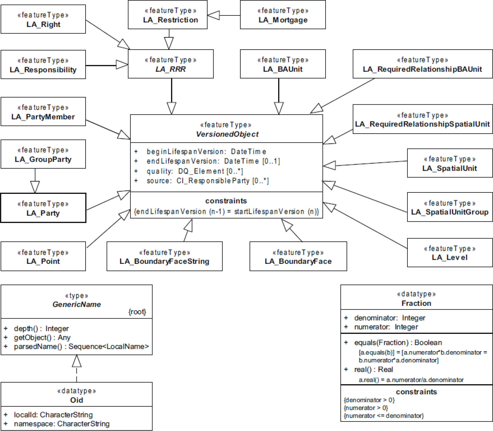
What’s more, some classes such as LA_Right (right), LA_Restriction (restrictions), LA_Responsibility (liabilities), LA_Mortgage (mortgage), by class LA_Restriction may inherit the version of the object from the source class. According to the standard, the VersionedObject attributes are as follows:
beginLifespanVersion, which is the start time of the object version;
endLifespanVersion, which is the end time of the object version;
quality, specifying the quality of the new version data (in accordance with ISO 19115-1 (2014)) and
source, specifying the source on the basis of which the change was made (in accordance with ISO 19115-1 (2014)).
In addition, the beginLifespanVersion attribute should match the endLifespanVersion attribute of the previous version of the object, so that you can maintain the relationship between them. The introduction and addition of the quality attribute is also a very important element because it allows documentation of the desirability of the changes introduced and assesses the quality of newer data by making it easier to find the source of documentation.
The standard also provides a set of tests of compliance with the conceptual scheme presented in ISO 19152 (2012). The actual use of LADM requires the development of an application scheme consistent with the country profile. Therefore, testing is to verify that the contents of the dataset match the appropriate LADM application scheme. Figure 1 provides an overview of the individual packages whose compatibility is required. We can see that virtually every object requires validation of the object version. This is the emphasis by legislators on the importance of this attribute. This obligation also applies to the LA_SpatialUnit class corresponding to a cadastral parcel.
. ISO 19157 – geographic information – data quality
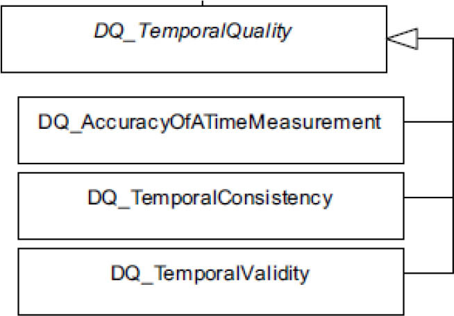
Regarding the quality of spatial data, including time data quality, the standard refers to ISO 19157 (2013): ‘geographic information – data quality’, where its definition can be found. According to this, the quality of time data is defined as the quality of time attributes and the temporal relationship between the features of the object. The dignity of the norm consists of three elements (Figure 6):
time measurement accuracy – as the closeness of the reported time measurements to the values accepted or recognised as adequate;
time consistency – correct order of events;
time validity – the validity of the data in relation to time.
In addition, standard time measurement can be defined both as a point as well as a certain period of time.
Table 1
LADM compliance requirements table (source: ISO 19152 (2012))
| LADM package | LADM class | CIa | Dependencies |
|---|---|---|---|
| Versioned Object | 1 | – | |
| – | LA_Source | 1 | Oid, (as a minimum one of the secializations must be implemented [LA_AdministrativeSource or LA_SpatialSource]), LA_AvailabiityStatusType |
| Party Packageb | LA_Party | 1 | VersionedObject, Oid, LA_PartyType |
| LA_GroupParty | 2 | Oid, La_Party, LA_GroupPartyType | |
| LA_PartyMember | 2 | VersionedObject, LA_Party, La_GroupParty | |
| Administrative Packagec | LA_RRR | 1 | VersionedObject, Oid, LA_Party, LA_BAUnit, LA_Right (as a minimum this specialization shall be implemented), LA_AdministrativeSource |
| LA_Right | 1 | LA_RRR, LA_RightType | |
| LA_Restriction | 2 | LA_RRR, LA_RestrictionType | |
| LA_Responsibility | 3 | LA_RRR, LA_ResponsibilityType | |
| LA_BAUnit | 1 | VersionedObject, Oid, LA_RRR, LA_BAUnitType | |
| LA_Mortgage | 2 | LA_Restriction | |
| LA_AdministrativeSource | 1 | LA_Source, LA_Party, LA_AdministrativeSourceType, La_AvailabilityStatusType | |
| La_RequiredRelationshipBAUnit | 3 | VersionedObject, LA_BAUnit | |
| Spatial Unit Package | LA_SpatialUnit | 1 | VersionedObject, Oid |
| LA_SpatialUnitGroup | 2 | VersionedObject, Oid, LA_SpatialUnit | |
| LA_LegalSpaceBuildingUnit | 3 | LA_SpatialUnit | |
| LA_LegalSpaceUtilityNetwork | 3 | LA_SpatialUnit | |
| LA_Level | 2 | VersionedObject, Oid | |
| LA_RequiredRelationshipSpatialUnit | 3 | VersionedObject, LA_SpatialUnit | |
| Surveying and Representation Subpackage | LA_Point | 2 | VersionedObject, LA_SpatialSource, LA_PointType, LA_InterpolationType |
| LA_SpatialSource | 2 | LA_Source, LA_Point, LA_Party, LA_SpatialSourceType | |
| LA_BoundaryFaceString | 2 | VersionedObject, Oid, LA_Point (if using geometry) | |
| LA_BoundaryFace | 3 | VersionedObject, Oid, LA_Point (if using geometry) | |
. INSPIRE
Another international standard covering the cadastre is the INSPIRE Directive (Directive, 2007) aimed at improving and increasing access to spatial data resources and strengthening cooperation between European institutions, which is based on the exchange or analysis of spatial data. It fulfils one of the most important conditions for the creation of an information society, which is universal access to spatial information created by public administration, necessary for both professional and personal purposes (Bujakowski and Pyka, 2009). The Directive is intended to harmonise the rules for the storage and provision of data and related services by state and public authorities. INSPIRE’s core objectives include the following:
Data should be obtained only once and stored and managed in the most correct and effective manner by relevant institutions and services.
Access to information on what spatial data is available and under which conditions it should be provided, as well as information enabling the user to assess the suitability of this data for its purposes.
We can, therefore, notice that already in the basic assumptions of the Directive, we have emphasised the need to store and share spatial data. What’s more, it is also important to specify metadata to evaluate spatial data.
Similar to the LADM standard (ISO 19152 2012), in the Directive (2007), we will find an application scheme of a cadastral parcel (Figure 8) understood as the basic area defined in the cadastre or an analogous register.
The INSPIRE Directive for the cadastral parcel suggests two validFrom and beginLifespanVersion attributes and validTo and endLifespanVersion attributes. It allows for the demarcation of the legal and physical creation or termination of the change resulting, for example, from the division or sale of the parcel. This specification may also refer to the recalculation of the plot area or improvement of border point attributes when we separate the moment of change in the centre and the actual change on the ground. When making temporary changes, the INSPIRE recommendation suggests either treating the plot after the change as a new one, with a new identifier, or as a new version of the same object with an unchanged identifier (Figure 7). In addition, archived data should be treated as metadata, found by the origin.
Due to the fact that the INSPIRE Directive and the ISO 19152 standard were simultaneously developed, coherence between these acts was ensured. The concept and compatibility of common names have been adjusted. Of course, there are some differences due to the different areas of application. The INSPIRE Directive places much more emphasis on users related to the environment, while the LADM ensures a multifunctional character and covers many more areas of application. However, thanks to intensive cooperation, simultaneous compliance with both standards is possible.
In order to demonstrate the compatibility of INSPIRE with ISO 19152, the Directive contains a LADM-based version of the INSPIRE cadastral plot (Figure 9).

You will notice that each object associated with the cadastral plot as well as the cadastral parcel itself has the attribute VersionedObject, which was also observed in the standard LADM. Four classes are relevant to the plot in accordance with the INSPIRE Directive:
LA_Parcel as the basis for CadastralParcel,
LA_LAUnit as the basis of BasicPropertyUnit,
LA_FaceString as the basis for CadastralBoundary,
LA_SpatialUnitSet as the basis for CadastralZoning.
In addition, attributes inherited by INSPIRE can have a more detailed data type and more detailed attributes.
. Comparison
Based on the analysis results presented in the article, it can be seen that in all three models represented by both Polish and international standards, the temporal attribute appears in the description of the cadastral parcel. It refers to both the date and time the object was created and transferred to the archive. The startVersionoObject attribute, responsible for disclosing the date of the new version of the object in the cadastre, corresponds to the beginLifespanVersion attribute contained in both the INSPIRE Directive and the LADM standard. On the other hand, the endVersionObject attribute responsible for entering the end date of the object’s version corresponds to the end LifespanVersion attributes (Figure 2). Both in Polish law (Regulation, 2001) and the Directive (2007), the dates of the very beginning and end of the whole facility are additionally listed. This is a useful attribute if there is no specification of its specific version, but their individual introduction greatly facilitates the creation of relationships and references to previous states. A very important element of the VersionObject attribute specified in the ISO standard (ISO 19152, 2012) is the introduction of the source of change and the quality of new data. This creates much more opportunities for data research and increases its reliability. In the Polish model, for the cadastral parcel, there is an attribute of information about the accuracy of the field, which, to some extent, can be pulled under the quality attribute; however, it should be extended at least by border points.
. Conclusion
According to the analysis of legal acts, Polish legislation allows archiving of data and the creation of newer versions of objects. The research confirmed the thesis that the legal regulations existing in Poland ensure the adaptation of the cadastre to international norms and standards in the context of creation or modification time data. The classes included in international standards have their equivalents in the Polish cadastre. The results of comparative analyses presented in the article show that the cadastral database is a good basis for creating a multifunctional cadastre, enabling the collection, search and analysis of time data, as well as easy examination of earlier legal states. However, this requires the authorities running the geodetic resource to archive outdated data, and not just replace it with newer data. In addition, a very important aspect is the introduction of the quality attribute of the data entered. However, this should not only apply to the entire cadastral parcel, but also to the individual border point.
Keeping cadastral data up to date is a very important aspect; however, it is the ease of reconstructing previous legal states that prevents the disruption of history and its manipulation, and the ability to check future burdens on land can be a great tool to support easy and more effective spatial policy.
